Bauneg Beg Mountain & Devil's Den at Bauneg Beg Mountain Conservation Area in North Berwick, Maine is a moderate 1.6-mile out-and-back (lollipop) hike that summits Bauneg Beg Mountain with views of the White Mountains on clear days in addition to a light rock scramble that leads to the Devil's Den, a large boulder field with rock ledges.
Trails
This hike follows three named trails in order (clockwise): Tom's Way (orange blazes), Linny's Way (red blazes), and Ginny's Way (yellow blazes).
Hike Description
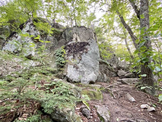
This hike begins along Bauneg Beg Hill Road at a very small parking turnout for the Tom's Way trail and follows the path along orange blazes as it meanders its way up Bauneg Beg Mountain. Tom's Way is mostly an easy trail, except for when the path gets closer to the summit of Bauneg Beg Mountain as it picks up in elevation grade slightly; however, this trail should be considered easy or moderate at worst. Along the way are some older-growth white pine, the trail substrate is mostly a soft bouncy pine-laden forest with some flat rocks for steps in some areas.
Linny's Way Junction - Mile 0.63
At mile 0.63, hikers will reach a 3-way junction with Linny's Way (red blazes) and Ginny's Way where Tom's Way ends near the summit. Take a left-hand turn here to hike along Linny's Way to reach the summit of Bauneg Beg Mountain.
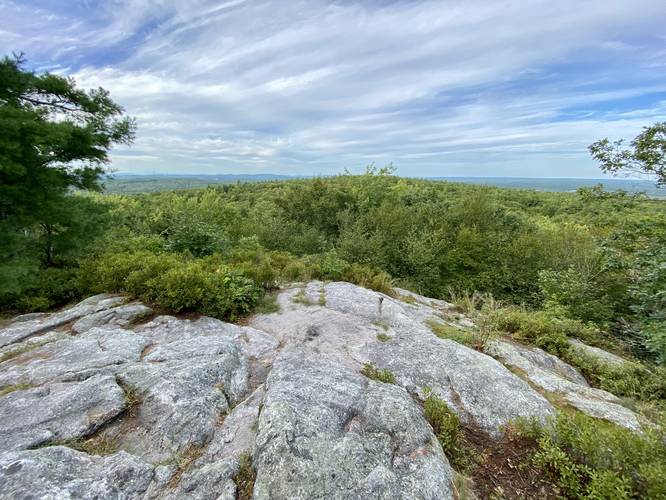
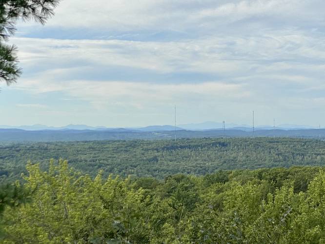
Bauneg Beg Mountain Summit - Mile 0.66
Around mile 0.66, hikers will reach the western summit of Bauneg Beg Mountain where the bedrock sprawls out toward steep ledges that sit high above the trees that overlook the Devil's Den area below. Here, on clear days, hikers can look northward to find the White Mountains in the distance. Mt. Washington sticks out like a sore thumb as its the highest peak on the horizon with its slowly-sloping western ridge that connects from Mt. Monroe. For those who've hiked Mt. Washington, this is a nice place to view your accomplishment from.
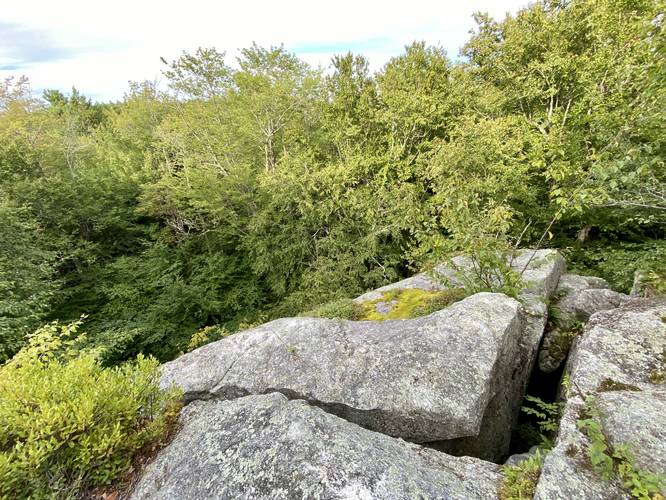
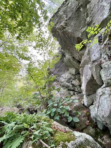
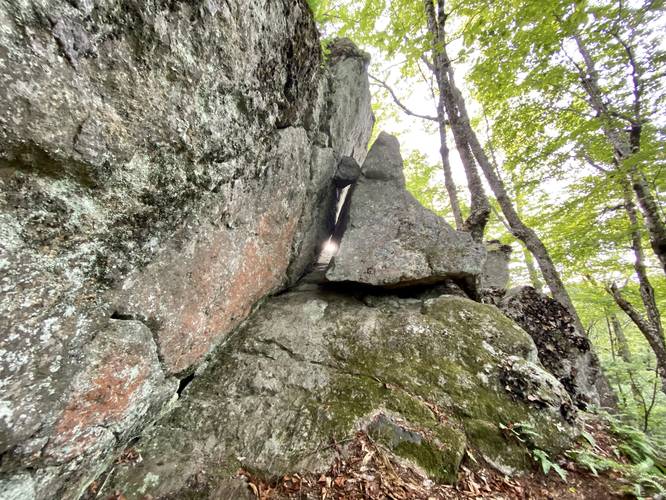
Reaching the Devil's Den - Mile 0.66 to 0.8
After visiting the summit of Bauneg Beg Mountain, hikers will continue following the red blazes of Linny's Way which follows a skinny path through the low-growing shrubs atop the mountain as it heads westward. Note that if you hike to a dead end that leads to a 50-foot rock cliff, you've hiked too far - head back 40-feet to find a hairpin turn that leads downhill along a rocky path that leads to the Devil's Den. This rocky path has a couple of spots where the hiker may want to sit down to use their hands to maneuver down the rocks; however, most would say this is barely a scramble. On the way down are some large rock overhangs near the cliffs and ledges with massive boulders scattered below - this is the heart of the Devil's Den. It's pretty fun to walk and scramble around on these boulders too. Just after passing through the Devil's Den, the trail will meander to the right - heading east - to reach Ginny's Way but not before passing the North Peak Loop junction (blue blazes). Note that there appears to be an unofficial path that leads west just before the bend in the trail, which likely leads to more of the Devil's Den boulders, crevasses, and ledges.
Ginny's Way to Tom's Way - Mile 0.85 to 1.05
After reaching Ginny's Way, hikers will want to follow this trail as it heads south and finally west to reach Tom's Way. The entire trail length is not very long, approximately 0.2-miles, but it does lead back uphill from approximately mile 0.85 to mile 1.05 in the track provided.
Hiking Out
Once at Tom's Way, the hike out is simply the opposite hike along Tom's Way to reach parking and to complete this hike as a "lollipop" (out-and-back with a loop).
Parking
Hikers will find parking at the coordinates provided - the roadside turnout is large enough to fit about 3 vehicles at most.
Pets
Dogs are allowed if leashed and their waste must be carried out by the hiker.
Warnings
Cliffs and crevasses: Bauneg Beg Mountain and the Devil's Den has steep and tall rock ledges that prevent trees from growing, thus the exposed area provides hikers with a view. These rock ledges also have large and deep crevasses in them, so watch your step as you explore the area.
Trails
This hike follows three named trails in order (clockwise): Tom's Way (orange blazes), Linny's Way (red blazes), and Ginny's Way (yellow blazes).
Hike Description
This hike begins along Bauneg Beg Hill Road at a very small parking turnout for the Tom's Way trail and follows the path along orange blazes as it meanders its way up Bauneg Beg Mountain. Tom's Way is mostly an easy trail, except for when the path gets closer to the summit of Bauneg Beg Mountain as it picks up in elevation grade slightly; however, this trail should be considered easy or moderate at worst. Along the way are some older-growth white pine, the trail substrate is mostly a soft bouncy pine-laden forest with some flat rocks for steps in some areas.
Linny's Way Junction - Mile 0.63
At mile 0.63, hikers will reach a 3-way junction with Linny's Way (red blazes) and Ginny's Way where Tom's Way ends near the summit. Take a left-hand turn here to hike along Linny's Way to reach the summit of Bauneg Beg Mountain.
Bauneg Beg Mountain Summit - Mile 0.66
Around mile 0.66, hikers will reach the western summit of Bauneg Beg Mountain where the bedrock sprawls out toward steep ledges that sit high above the trees that overlook the Devil's Den area below. Here, on clear days, hikers can look northward to find the White Mountains in the distance. Mt. Washington sticks out like a sore thumb as its the highest peak on the horizon with its slowly-sloping western ridge that connects from Mt. Monroe. For those who've hiked Mt. Washington, this is a nice place to view your accomplishment from.
Reaching the Devil's Den - Mile 0.66 to 0.8
After visiting the summit of Bauneg Beg Mountain, hikers will continue following the red blazes of Linny's Way which follows a skinny path through the low-growing shrubs atop the mountain as it heads westward. Note that if you hike to a dead end that leads to a 50-foot rock cliff, you've hiked too far - head back 40-feet to find a hairpin turn that leads downhill along a rocky path that leads to the Devil's Den. This rocky path has a couple of spots where the hiker may want to sit down to use their hands to maneuver down the rocks; however, most would say this is barely a scramble. On the way down are some large rock overhangs near the cliffs and ledges with massive boulders scattered below - this is the heart of the Devil's Den. It's pretty fun to walk and scramble around on these boulders too. Just after passing through the Devil's Den, the trail will meander to the right - heading east - to reach Ginny's Way but not before passing the North Peak Loop junction (blue blazes). Note that there appears to be an unofficial path that leads west just before the bend in the trail, which likely leads to more of the Devil's Den boulders, crevasses, and ledges.
Ginny's Way to Tom's Way - Mile 0.85 to 1.05
After reaching Ginny's Way, hikers will want to follow this trail as it heads south and finally west to reach Tom's Way. The entire trail length is not very long, approximately 0.2-miles, but it does lead back uphill from approximately mile 0.85 to mile 1.05 in the track provided.
Hiking Out
Once at Tom's Way, the hike out is simply the opposite hike along Tom's Way to reach parking and to complete this hike as a "lollipop" (out-and-back with a loop).
Parking
Hikers will find parking at the coordinates provided - the roadside turnout is large enough to fit about 3 vehicles at most.
Pets
Dogs are allowed if leashed and their waste must be carried out by the hiker.
Warnings
Cliffs and crevasses: Bauneg Beg Mountain and the Devil's Den has steep and tall rock ledges that prevent trees from growing, thus the exposed area provides hikers with a view. These rock ledges also have large and deep crevasses in them, so watch your step as you explore the area.