The Battery Steele Trail on Peaks Island, Maine is an easy and popular 0.5-mile loop hike that leads through the abandoned WWII military fortification which features graffiti, a long dark tunnel, and lots of mud.
Hike Description
This hike begins along Seashore Ave near the trailhead coordinates provided and leads in along a skinny and overgrown marshy trail. This section of the trail is an out-and-back that includes wooden planks sitting in the mud to keep hikers from getting their feet soaked with water or caked in mud. The wooden planks can be a bit tricky to walk on in places and based on the trail's traffic, sometimes you have to move over or wait for other hikers to pass-by, given very-minimal space. If you show up earlier in the morning, running into other hikers is less-likely.
Loop Split - Mile 0.1
Around mile 0.1, hikers will reach a left and right-hand turn in the trail. This recording heads to the left-hand side which leads to the southern end of Battery Steele.
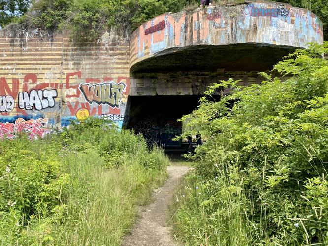
Battery Steele South Entrance - Mile 0.18
Around mile 0.18, hikers will reach the southern entrance to Battery Steele where they'll also find a plethora of graffiti, as of July 2023. For those who wish to walk through the entire facility, you can enter the complex here and then head into the rooms and long tunnel.
Battery Steele Tunnel - Mile 0.2 to 0.3
From mile 0.2 to 0.3, hikers will walk through the super-dark Battery Steele tunnel which only provides daylight from each end of the 0.1-mile long tunnel. Use your flashlight to navigate through and check out some creepy and dark off-shoot rooms along the way. This entire tunnel is filled with graffiti and is dark, dank, and cool during hot Summer days.
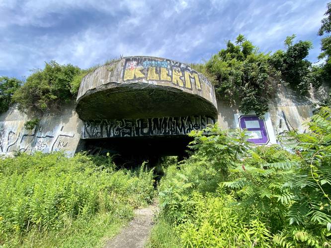
Battery Steele North Entrance - mile 0.3
At mile 0.3, hikers will exit the north entrance of Battery Steele where they'll find more colorful graffiti. The trail from here back to the out-and-back section of the hike is generally overgrown. As of July 2023 it seemed like a lot of people hike this as an out-and-back instead of following the loop due to the overgrowth of tall grasses; however, you can choose your own adventure.
Once back at the loop, the hike out follows the same out-and-back trail you hiked-in on. Just watch (or listen) for hikers coming down the wooden planks as the tall reeds and grass block your view of oncoming foot traffic.
Parking
If driving, there are some small parking turnouts near the coordinates provided. The parking turnouts are mostly for golf carts, which can be rented on the island.
Pets
Dogs are allowed if leashed and should be cleaned up after.
Battery Steele History
Battery Steele was part of a comprehensive program begun in 1940 to replace obsolete coast defenses, many of which dated from the Endicott Program of 1885-1905. Completed in 1942 as part of World War II it is located on 14 acres on the oceanside area of the island, formerly part of the Peaks Island Military Reservation. On October 20, 2005, the property was listed on the National Register of Historic Places. Read more about Battery Steele on wikipedia.
Getting to and Getting Around Peaks Island
To access Peaks Island, travelers must buy a ticket from Casco Bay Lines to hitch a ride on the ferry in Portland. Peaks Island ferry runs on a different schedule each season and year. Please use this Casco Bay Lines link to find out more about when the ferry leaves Portland and/or Peaks Island to plan your trip. As of July 2023, the price for a ticket to Peaks Island cost $7 for one adult and there's no return fee as the trip from Peaks Island to Portland is free. Visitors can pay more money to bring their cars, however, folks that bring vehicles to Peaks Island are generally locals. Instead, visitors can either plan to walk/hike the island or they can rent golf carts for a moderate hourly fee on the island. Each golf cart rental business, as of July 2023, is located right off of the dock where the ferry drops passengers off on the island. On our trip we used Mike's Carts which cost $50/hour to rent the golf cart for up to 5 hours max. Mike's Carts, as of July 2023, did not require prior reservations, however, any first-come first-serve carts might sell out by late morning. There's another company called Peaks Island Golf Carts which require a reservation in advance. Last, weekends on Peaks Island - especially during the Summer - can be very very busy. If you wish to explore Peaks Island without a massive crowd, plan on a quiet weekday.
Hike Description
This hike begins along Seashore Ave near the trailhead coordinates provided and leads in along a skinny and overgrown marshy trail. This section of the trail is an out-and-back that includes wooden planks sitting in the mud to keep hikers from getting their feet soaked with water or caked in mud. The wooden planks can be a bit tricky to walk on in places and based on the trail's traffic, sometimes you have to move over or wait for other hikers to pass-by, given very-minimal space. If you show up earlier in the morning, running into other hikers is less-likely.
Loop Split - Mile 0.1
Around mile 0.1, hikers will reach a left and right-hand turn in the trail. This recording heads to the left-hand side which leads to the southern end of Battery Steele.
Battery Steele South Entrance - Mile 0.18
Around mile 0.18, hikers will reach the southern entrance to Battery Steele where they'll also find a plethora of graffiti, as of July 2023. For those who wish to walk through the entire facility, you can enter the complex here and then head into the rooms and long tunnel.
Battery Steele Tunnel - Mile 0.2 to 0.3
From mile 0.2 to 0.3, hikers will walk through the super-dark Battery Steele tunnel which only provides daylight from each end of the 0.1-mile long tunnel. Use your flashlight to navigate through and check out some creepy and dark off-shoot rooms along the way. This entire tunnel is filled with graffiti and is dark, dank, and cool during hot Summer days.
Battery Steele North Entrance - mile 0.3
At mile 0.3, hikers will exit the north entrance of Battery Steele where they'll find more colorful graffiti. The trail from here back to the out-and-back section of the hike is generally overgrown. As of July 2023 it seemed like a lot of people hike this as an out-and-back instead of following the loop due to the overgrowth of tall grasses; however, you can choose your own adventure.
Once back at the loop, the hike out follows the same out-and-back trail you hiked-in on. Just watch (or listen) for hikers coming down the wooden planks as the tall reeds and grass block your view of oncoming foot traffic.
Parking
If driving, there are some small parking turnouts near the coordinates provided. The parking turnouts are mostly for golf carts, which can be rented on the island.
Pets
Dogs are allowed if leashed and should be cleaned up after.
Battery Steele History
Battery Steele was part of a comprehensive program begun in 1940 to replace obsolete coast defenses, many of which dated from the Endicott Program of 1885-1905. Completed in 1942 as part of World War II it is located on 14 acres on the oceanside area of the island, formerly part of the Peaks Island Military Reservation. On October 20, 2005, the property was listed on the National Register of Historic Places. Read more about Battery Steele on wikipedia.
Getting to and Getting Around Peaks Island
To access Peaks Island, travelers must buy a ticket from Casco Bay Lines to hitch a ride on the ferry in Portland. Peaks Island ferry runs on a different schedule each season and year. Please use this Casco Bay Lines link to find out more about when the ferry leaves Portland and/or Peaks Island to plan your trip. As of July 2023, the price for a ticket to Peaks Island cost $7 for one adult and there's no return fee as the trip from Peaks Island to Portland is free. Visitors can pay more money to bring their cars, however, folks that bring vehicles to Peaks Island are generally locals. Instead, visitors can either plan to walk/hike the island or they can rent golf carts for a moderate hourly fee on the island. Each golf cart rental business, as of July 2023, is located right off of the dock where the ferry drops passengers off on the island. On our trip we used Mike's Carts which cost $50/hour to rent the golf cart for up to 5 hours max. Mike's Carts, as of July 2023, did not require prior reservations, however, any first-come first-serve carts might sell out by late morning. There's another company called Peaks Island Golf Carts which require a reservation in advance. Last, weekends on Peaks Island - especially during the Summer - can be very very busy. If you wish to explore Peaks Island without a massive crowd, plan on a quiet weekday.