Bates Ferry Trail & General Greene Tree hike at Congaree National Park near Wateree, South Carolina is an easy 2.7-mile out-and-back hike that features a beautiful old-growth Bald Cypress tree and views of the Congaree River.
Hike
This hike begins at the main trailhead for the Bates Ferry Trail, located at the parking lot on the west side of US-601. The trailhead includes a kiosk with historical information about the Bates Ferry and the purpose of this old road, which is now a public use trail. Hikers may want to simply walk to see the Congaree River, but along the way is a lesser-known old-growth Bald Cypress tree known as the General Greene Tree that sits down a side trail off of the Bates Ferry Trail.
Finding the General Greene Tree - Mile 0 to 0.65
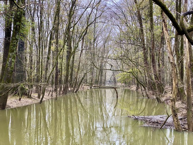
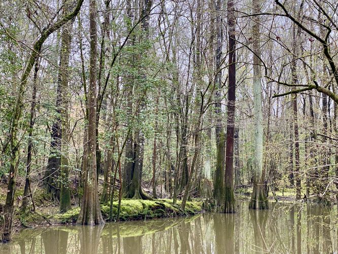
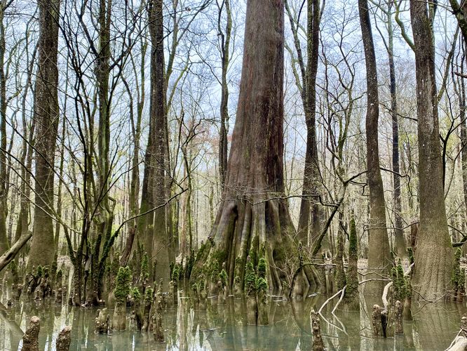
Hikers will head down the Bates Ferry Trail as it passes through the woods along a mostly-flat trail. Around mile 0.4 are some points-of-interest that help find the trail that leads to the General Greene Tree. First, at mile 0.4 is a sign post labeled "#7" which defines this national park trail. On the left-hand side is an unmaintained trail or service road. Just up ahead, about 200-feet from the sign labeled "#7" is a trail. As of March 2024, there was an old rusty staircase that marked the turn to the trail. Take this right-hand turn to hike the unmarked trail as it leads out to the old-growth Bald Cypress. You know you're on the right trail when you quickly reach a large metal bridge that spans a very-wide creek. Hike across the bridge then jump across a small creek tributary -- the trail will then begin to bend to the northwest. Approximately 200-feet down the trail from where it begins to bend is the large old-growth Bald Cypress known as the General Greene Tree. Here, assuming there's no flooding, you can take pictures from the edge of the swamp where the trees "knees" or roots jut out of the ground. This scenic tree is by far the most-interesting thing on the hike, but it's worth exploring the rest of the Bates Ferry Trail, so hikers will head back that way after exploring this old-growth.
Bates Ferry Trail to Congaree River - Mile 0.8 to 1.5
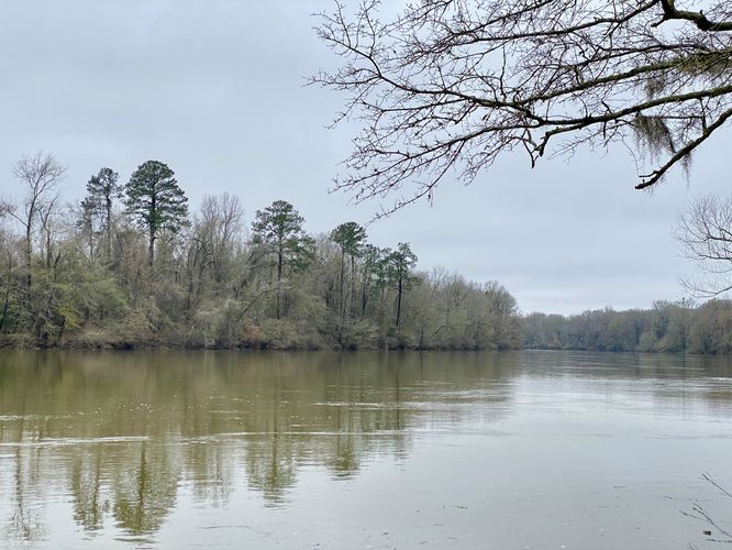
After exploring the General Greene Tree, hikers will head southwest along the Bates Ferry Trail to reach the Congaree River. Along the way are interpretive signs that include historical facts from the area, including information on General Greene. Hikers will also find wildflowers like the Carolina Jasmine growing along the trail in addition to a scenic Cypress-Tupelo swamp located around mile 1.25 on the southern side of the trail. Finally, at mile 1.5, hikers will reach the banks of the Congaree River. From the banks of the river, you can take in the views of the Congaree before heading back to parking.
The hike back is easy as it follows the mostly-flat, wide, dirt trail you hiked in on. As of March 2024, there was at least one section of blowdown trees that had to be navigated around, but otherwise was an easy walk in the woods.
Parking
Hikers will find a small parking lot at the coordinates provided, located on the west side of US-601 near Wateree, SC. The lot is large enough to fit a half-dozen vehicles as of March 2024.
Pets
Dogs are allowed only if leashed and must be cleaned up after.
History
The Bates Ferry Trail is a historical route that once connected the cities of Camden and Charleston. Long before there were trains or automobiles, simple paths like this one connected distant communities, promote economic growth, and provided lines of communication. As far back as the mid-1700s this and other nearby roads were used by people from all levels of South Carolina's highly stratified society. Once travelers arrived at the Congaree River, their journey wasn't over but rather was met with a new challenge to cross the river. A ferry, hopefully, would be waiting for them to help them cross. Throughout time, this route relied on ferries at various locations to cross the Congaree. One of the earliest ferries was McCord's Ferry, located east of the Bates Ferry Trail trailhead on Bates Old River. Bates Ferry was located at the end of this trail. Colonists began building private ferries on the Congaree River in the 1740s. In 1766 John McCord's ferry became the first public crossing in this area. Government regulated public ferries guaranteed travelers a safe river crossing at a fair price. As the river's channel changed, so did the location and number of ferries. By the 1840s, a lake developed south of the crossing at McCord's Ferry and a separate ferry was constructed here. An 1852 flood cut the river's new channel through this lake. By 1865 river crossing was known as Bates Ferry. Most ferries were constructed in a flat boat form. In deep rivers, ferrymen pulled the ferry ropes by hand along a rope or chain that stretched across the river. From the colonial period to the Civil War, ferries were often built and operated by slaves.
Warnings
Mosquitos: Note that Congaree National Park is known for its insane-levels of mosquitos (and other bugs). The visitors center has a mosquito meter located between the two restrooms near the trailhead. The mosquito meter ranges between 1 (All Clear) to 6 (War Zone). If you want to enjoy Congaree National Park with minimal mosquito issues, plan to visit during the winter. During our hike here in early March 2024, we didn't have to deal with any mosquitos. During Summer months, the meter is likely always at 6 "War Zone".
Flooding: Heavy rains can flood parts of this boardwalk, especially on the western side.
Rattlesnakes: This area is home to the Timber Rattlesnake which can be found sunning itself in open areas or sunny spots on warm days. Despite the popularity of this boardwalk, you could encounter a snake as it roams the forest. If you find a rattlesnake give it plenty of space.
What makes Congaree Special?
Congaree National Park is comprised of floodplains that sit alongside the Congaree River. Historically, these floodplains have been difficult to navigate and plunder for natural resources like timber. Due to the difficulties in logging the floodplain forests, Congaree holds a unique ecosystem of old-growth Bald Cypress and Water Tupelo trees -- along with other old-growth trees native to the eastern United States like various types of Maples. Due to the lack of logging, Congaree also holds one of the tallest deciduous canopies in the world. Tall Loblolly Pine trees also grow in Congaree's floodplains and some even reach as tall as 150-feet high. Congaree's unique swampy ecosystem is also full of various bird species and makes for a very-popular bird watching park. During our visit in March 2024, we saw at least one owl, many cardinals, and various other species of birds that we (being from the north) only see during certain seasons of the year.
Hike
This hike begins at the main trailhead for the Bates Ferry Trail, located at the parking lot on the west side of US-601. The trailhead includes a kiosk with historical information about the Bates Ferry and the purpose of this old road, which is now a public use trail. Hikers may want to simply walk to see the Congaree River, but along the way is a lesser-known old-growth Bald Cypress tree known as the General Greene Tree that sits down a side trail off of the Bates Ferry Trail.
Finding the General Greene Tree - Mile 0 to 0.65
Hikers will head down the Bates Ferry Trail as it passes through the woods along a mostly-flat trail. Around mile 0.4 are some points-of-interest that help find the trail that leads to the General Greene Tree. First, at mile 0.4 is a sign post labeled "#7" which defines this national park trail. On the left-hand side is an unmaintained trail or service road. Just up ahead, about 200-feet from the sign labeled "#7" is a trail. As of March 2024, there was an old rusty staircase that marked the turn to the trail. Take this right-hand turn to hike the unmarked trail as it leads out to the old-growth Bald Cypress. You know you're on the right trail when you quickly reach a large metal bridge that spans a very-wide creek. Hike across the bridge then jump across a small creek tributary -- the trail will then begin to bend to the northwest. Approximately 200-feet down the trail from where it begins to bend is the large old-growth Bald Cypress known as the General Greene Tree. Here, assuming there's no flooding, you can take pictures from the edge of the swamp where the trees "knees" or roots jut out of the ground. This scenic tree is by far the most-interesting thing on the hike, but it's worth exploring the rest of the Bates Ferry Trail, so hikers will head back that way after exploring this old-growth.
Bates Ferry Trail to Congaree River - Mile 0.8 to 1.5
After exploring the General Greene Tree, hikers will head southwest along the Bates Ferry Trail to reach the Congaree River. Along the way are interpretive signs that include historical facts from the area, including information on General Greene. Hikers will also find wildflowers like the Carolina Jasmine growing along the trail in addition to a scenic Cypress-Tupelo swamp located around mile 1.25 on the southern side of the trail. Finally, at mile 1.5, hikers will reach the banks of the Congaree River. From the banks of the river, you can take in the views of the Congaree before heading back to parking.
The hike back is easy as it follows the mostly-flat, wide, dirt trail you hiked in on. As of March 2024, there was at least one section of blowdown trees that had to be navigated around, but otherwise was an easy walk in the woods.
Parking
Hikers will find a small parking lot at the coordinates provided, located on the west side of US-601 near Wateree, SC. The lot is large enough to fit a half-dozen vehicles as of March 2024.
Pets
Dogs are allowed only if leashed and must be cleaned up after.
History
The Bates Ferry Trail is a historical route that once connected the cities of Camden and Charleston. Long before there were trains or automobiles, simple paths like this one connected distant communities, promote economic growth, and provided lines of communication. As far back as the mid-1700s this and other nearby roads were used by people from all levels of South Carolina's highly stratified society. Once travelers arrived at the Congaree River, their journey wasn't over but rather was met with a new challenge to cross the river. A ferry, hopefully, would be waiting for them to help them cross. Throughout time, this route relied on ferries at various locations to cross the Congaree. One of the earliest ferries was McCord's Ferry, located east of the Bates Ferry Trail trailhead on Bates Old River. Bates Ferry was located at the end of this trail. Colonists began building private ferries on the Congaree River in the 1740s. In 1766 John McCord's ferry became the first public crossing in this area. Government regulated public ferries guaranteed travelers a safe river crossing at a fair price. As the river's channel changed, so did the location and number of ferries. By the 1840s, a lake developed south of the crossing at McCord's Ferry and a separate ferry was constructed here. An 1852 flood cut the river's new channel through this lake. By 1865 river crossing was known as Bates Ferry. Most ferries were constructed in a flat boat form. In deep rivers, ferrymen pulled the ferry ropes by hand along a rope or chain that stretched across the river. From the colonial period to the Civil War, ferries were often built and operated by slaves.
Warnings
Mosquitos: Note that Congaree National Park is known for its insane-levels of mosquitos (and other bugs). The visitors center has a mosquito meter located between the two restrooms near the trailhead. The mosquito meter ranges between 1 (All Clear) to 6 (War Zone). If you want to enjoy Congaree National Park with minimal mosquito issues, plan to visit during the winter. During our hike here in early March 2024, we didn't have to deal with any mosquitos. During Summer months, the meter is likely always at 6 "War Zone".
Flooding: Heavy rains can flood parts of this boardwalk, especially on the western side.
Rattlesnakes: This area is home to the Timber Rattlesnake which can be found sunning itself in open areas or sunny spots on warm days. Despite the popularity of this boardwalk, you could encounter a snake as it roams the forest. If you find a rattlesnake give it plenty of space.
What makes Congaree Special?
Congaree National Park is comprised of floodplains that sit alongside the Congaree River. Historically, these floodplains have been difficult to navigate and plunder for natural resources like timber. Due to the difficulties in logging the floodplain forests, Congaree holds a unique ecosystem of old-growth Bald Cypress and Water Tupelo trees -- along with other old-growth trees native to the eastern United States like various types of Maples. Due to the lack of logging, Congaree also holds one of the tallest deciduous canopies in the world. Tall Loblolly Pine trees also grow in Congaree's floodplains and some even reach as tall as 150-feet high. Congaree's unique swampy ecosystem is also full of various bird species and makes for a very-popular bird watching park. During our visit in March 2024, we saw at least one owl, many cardinals, and various other species of birds that we (being from the north) only see during certain seasons of the year.