Loading...

🎆 50% off 4th of July sale on Supporter Accounts — now through July 6! Learn More.

Austin Dam Trail

Directions
Map
Pictures
Send to App
Distance:
1.5 Miles / 2.4 km
Type:
Out-and-Back
Difficulty:
Easy
Time to Hike:
~45 minutes
Features:
PA Wilds
Surface Type:
Dirt
Park:
Austin Dam Memorial Park
Town:
Austin, Pennsylvania
Directions:
41.652237, -78.085561
Added:
September 30, 2019
Updated:
February 25, 2024
Copy Trail Link Hiking this trail? Send a friend or family member a link to this trail guide for your own safety. Hike at your own risk (disclaimer)
Loading...
Loading...
108'

Total Change
190'

Ascent
147'

Descent

Download the Trail Route for Offline Use

Supporters get exclusive access to download trail routes to the MyHikes app for offline use. Stay prepared on your adventure, even without an internet connection! Become a Supporter today to unlock this feature and hike with confidence.

Send to App

Austin Dam Trail

The Austin Dam Trail at the Austin Dam Memorial Park in Austin, Pennsylvania is an easy 1.5-mile out-and-back hike that features the ruins of the Austin Dam. The hike explores the three different dams at the Austin Dam Memorial Park that were built to provide water for the Bayless Pulp & Paper Company during its operation from 1901 to 1944.

Trails: Note that this hike follows the Joseph Dumohoski Interpretive Hiking Trail. This trail runs from the Bayless Concrete Dam and follows the creek until it reaches the remains of the Bayless Earthen (Dirt) in the northern section of the park. Also note that this recording does not cover the entire length of all of the trails in the park (we will add this data in late Spring 2020 to include the whole trail system).

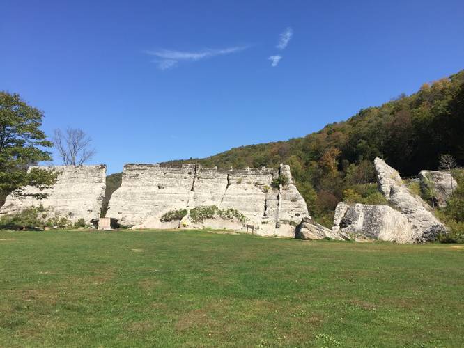
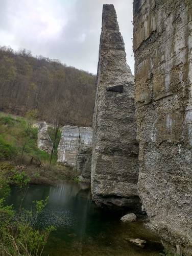
This recording begins at the parking lot below the concrete dam ruins and follows the trail that passes through the left-side of the ruins. Hikers will find massive pieces of rebar sticking out of the concrete slabs, massive chunks of concrete, and some pieces of dam that have fallen off over time. Be cautious when exploring around the dam and pay attention to and follow directions from the "stay out" signs. And remember, hike at your own risk.

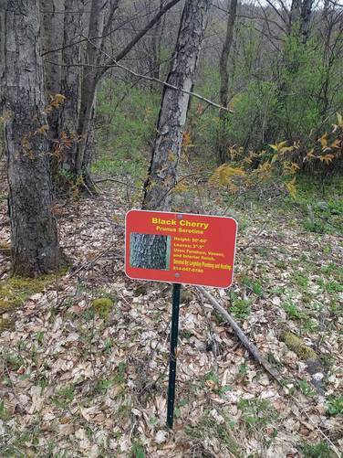
Along this trail are interpretive signs that explain local trees and vegetation. These signs also include local sponsors that help with the Austin Dam Memorial Association's efforts.

On the upstream side of the concrete dam, hike begins with the exploration to some small vernal pools that collect water over time. On this side of the concrete dam also begins the Joseph Dumohoski Interpretive Hiking Trail. The towering structures of concrete are really neat, despite the tragic loss of life caused by the concrete dam's breakage. The concrete dam was built in 1909 by C. J. Brintnall & Co., of Binghamton N. Y. and T. C. Hatton, Dam Engineer of Delaware for a larger water source for the Bayless Pulp & Paper Company.

This recording then follows the Joseph Dumohoski Interpretive Hiking Trail to the north. At about 0.3 miles, the hike explores the Coffer Dam. The Coffer Dam was built about 1901 by the Austin Borough, and was the initial water source for the Bayless Pulp & Paper Company. The Coffer dam was swept away in the 1911 concrete dam failure and only the hand-laid stone spillway remains today.

At the end of this hike, at about 0.8 mile distance north of the concrete dam, lays the ruins of the Earthen Dam. This structure, which began as a log crib dam, was built in 1910 by G. M. Miller, of Kane, PA, after the winter scare of January 1910 when the large newly-built concrete dam began to show signs of failure. The log-crib dam held intact during the 1911 flood, and was later reinforced with sloped earthen banks, and was used to re-open the Bayless Pulp & Paper Company after the concrete dam failure. The center section of this Earthen dam breached in the 1942 flood, and today the remaining sections are known by locals as the dirt dam.

History
On September 30th, 1911 the Bayless Pulp & Paper Company concrete dam gave way under tons of pressure from the water in the reservoir which had been built to help fuel the paper mill just south of the reservoir. The dam breakage sent water rushing down the valley, destroying everything in its path - including much of the paper mill. The water rushed right through the town of Austin as well. In its wake, it killed 78 people in total.

Bayless Pulp & Paper Company survived the breaking of the Austin Dam in 1911 as well as the smaller earthen dam break in the flood of 1942. However, a major fire in 1944 caused the Austin papermill to close forever.

Pets
Dogs are allowed if leashed and their waste must be carried out by the hiker.

Parking
Hikers can find parking at the main lot for Austin Dam. The entrance sign, located on PA Route-872, has two roads that lead out from it. Follow the road that immediately crosses a small bridge - do not drive down the hill to the camping area since the Austin Dam is about 1-mile away from this spot. Following the road that crosses the bridge will bring you down to the concrete dam.
Explore 102 trails near Austin, PA
  1. Parking

    41.652237, -78.085561
  2. Main Trailhead

    41.652319, -78.085678
  3. Austin Dam ruins

    41.652308, -78.085372
    Austin Dam ruins
  4. Bayless Concrete Dam Ruins

    41.653102, -78.085742
    Bayless Concrete Dam Ruins
  5. Coffer Dam Ruins (East Bank)

    41.655319, -78.084866
    Coffer Dam Ruins (East Bank)
  6. Coffer Dam Ruins (Spillway)

    41.655268, -78.085305
    Coffer Dam Ruins (Spillway)
  7. Earthen (Dirt) Dam Ruins

    41.659749, -78.088528
    Earthen (Dirt) Dam Ruins
  8. Interpretive Signage

    41.657153, -78.086729
    Interpretive Signage
  9. Jos. Dumohoski Trail

    41.657835, -78.087383
    Jos. Dumohoski Trail
No community routes found. To add your own hike as a Community Route for this Trail guide, leave a Trip Report with an attached GPX file.

Hazards

Ticks - Lyme Disease More Info (CDC)

Seasons

All

Trip Reports

Trail Guide By:
Admin user profile picture
1.5 miles / 2.4 km
0.6 miles / 1.0 km
September 28, 2019
Dogs Hiking

Weather Forecast

In Austin, PA

Explore Hiking Trails

You May Also Like

Colorado's Million Dollar Highway - Plan a day's drive adventure along the iconic Million Dollar Highway in Colorado. Explore the best short trails, roadside stops, waterfalls, vistas, ghost towns, and hot springs within a ~6 hour road trip.
Explore

Colorado's Million Dollar Highway

Plan a day's drive adventure along the iconic Million Dollar Highway in Colorado. Explore the best short trails, roadside stops, waterfalls, vistas, ghost towns, and hot springs within a ~6 hour road trip.

Read
New York's Best Waterfalls - Whether you're planning a day hike, roadside stop, or a leisurely short walk, this guide provides hikers, travelers, and locals alike with 63 different locations to over 100 scenic waterfalls to help plan your next adventure!
Explore

New York's Best Waterfalls

Whether you're planning a day hike, roadside stop, or a leisurely short walk, this guide provides hikers, travelers, and locals alike with 63 different locations to over 100 scenic waterfalls to help plan your next adventure!

Read

Before you boogie...

Find our trail guides useful? Consider becoming a Supporter to unlock perks!

MyHikes is an indie platform that makes exploring public trails easier for everyone. The platform has no investors, no ads, and is owned and operated by one person, Dave Miller. Dave has personally mapped and written over 1,800 trail guides on MyHikes for the public to explore. MyHikes has helped millions outdoor enthusiasts plan their next adventure.

But it takes a lot of time 🕦, money 💰, work, and espresso shots ☕ to run MyHikes, including hiking , mapping , writing , and publishing new trails with high-quality (accurate) information... along with software engineering (coding) the platform like building new features, website and mobile app development (iOS and Android), site maintainance . and much much more.

Supporters unlock website and mobile app perks with an annual one-time payment of $25 (you renew) 😎👍. Or you can simply make a Donation of your choice. Otherwise, you can support us by telling your friends about MyHikes - both quick and free 🎉

Admin user profile picture

Dave Miller
MyHikes Founder