The Artists Rock, Sunset Rock, and Newman's Ledge hike at Catskill Park near Haines Falls, New York is a moderate 2.7-mile out-and-back hike that features views of the Hudson River Valley and the mountains surrounding North-South Lake.
Trails
This hike follows the Escarpment Trail (blue blazes) for the majority of the hike. Hikers will follow an unnamed yellow blazed trail out-and-back that will lead off of the Escarpment Trail and over to Sunset Rock.
Hike Description
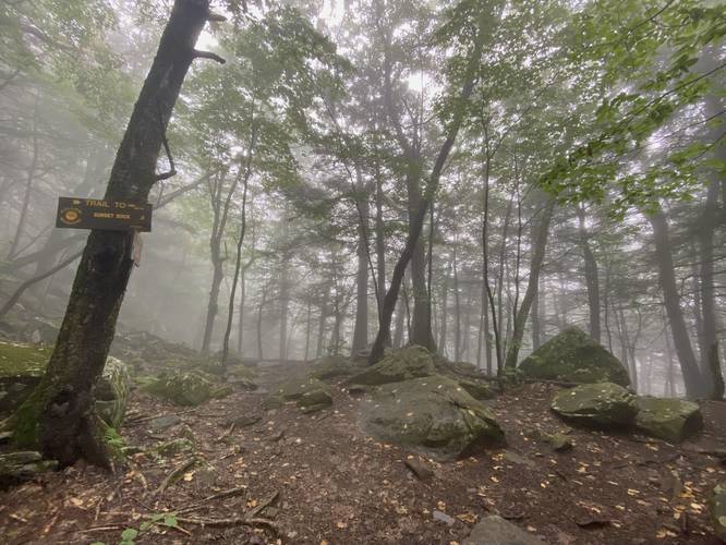
This hike begins near the end of North Lake Road where hikers will find the trailhead located just north of the large parking lot. The trail leads in along a yellow-blazed trail which leads to the blue-blazed Escarpment Trail.
Right-Hand turn / Escarpment Trail - Mile 0.1
Around mile 0.1, hikers will reach a trail junction with the Escarpment Trail. As of September 2023, there's no signage so this junction is easy to miss. If you hike to a dead-end or a curve in the trail that leads back to the road, you've hiked down the wrong path.
Rock Scramble, Ledges, Left-Turn - Mile 0.2
Around mile 0.2, hikers will reach a rocky ledge where the trail looks like it heads straight along the rocks, but instead it heads up to the left-hand side along a short series of scrambling.
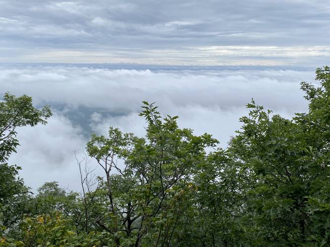
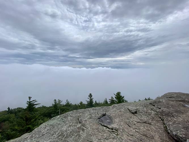
Artists Rock / Hudson River Valley Vista - Mile 0.4
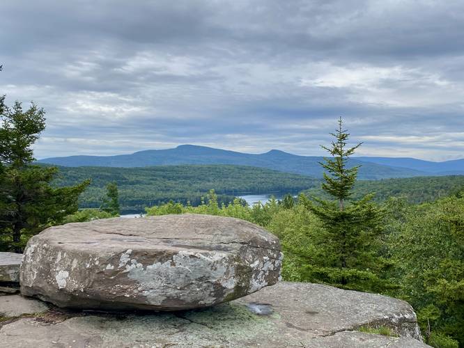
At mile 0.4, hikers will reach Artists Rock, a steep and tall bedrock ledge that provides sweeping views of the Hudson River Valley and the Berkshire mountain range to the east. On cloudy days, the views may be blocked by the fog and clouds though, like on our hike here.
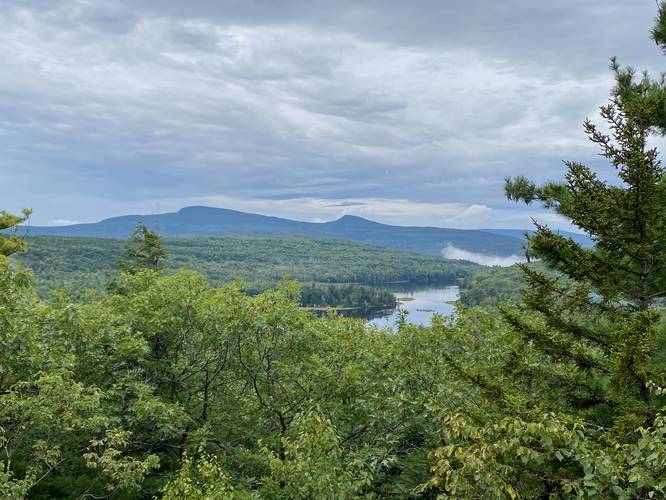
Lakes & Mountain Vista - Mile 0.55
Around mile 0.55, hikers will reach an unofficial off-shoot trail that leads into the woods for a very short distance - this trail leads to a really nice view of North and South Lake along with the mountains that tower above like Kaaterskill High Peak and Roundtop Mountain.
Optional Rock Scramble - Mile 0.75
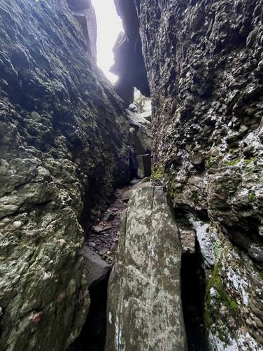
At mile 0.75, hikers will reach a very-optional rock scramble that may catch your eye. If you look up to the large rocky outcropping, where Sunset Rock sits atop, you might find a very large and wide crack in the rocks that leads to some cave-like features. You can scramble up the rocks here to ~30-feet above the trail to find a fun scrambling crag. If you're daring enough, you can scramble the remaining ~10 feet to reach Sunset Rock and the views above.
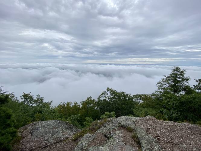
Hiking to Sunset Rock - Mile 0.75 to 1.16
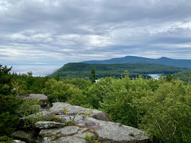
After passing the optional rock scramble, hikers will navigate around the massive bedrock outcropping, passing various types of rock ledges along the way, to reach a trail junction around mile 0.95 which leads to Sunset Rock. Take a right-hand turn here. Along the way, hikers will find another ledge overlook, located around mile 1.05. Continuing down the trail, hikers will finally reach Sunset Rock around mile 1.16. Sunset Rock sits atop the bedrock outcropping, as if balancing, and provides stunning views of North & South Lakes in addition to the mountains and steep drop-offs into the Hudson River Valley. On a cloudy day, despite a lack of views into the Hudson River Valley, the clouds form a swirling display along the mountain front. Note that the large hole just below Sunset Rock is the optional scramble from earlier in the hike - aka Hot Box Rock.
Hudson River Valley Overlook - Mile 1.25
On your way out from Sunset Rock, you may explore around the large rock crevasses, but you'll also notice another overlook of the Hudson River Valley around mile 1.25.
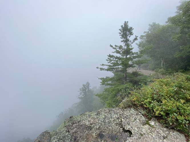
Hiking to Newman's Ledge - Mile 1.25 to 1.6
From the bedrock outcropping that Sunset Rock sits atop, at mile 1.25, the hike to Newman's Ledge begins. Hike out along this yellow-blazed out-and-back trail to reach the blue blazes of the Escarpment Trail. Once on the Escarpment Trail, you'll be on your way to Newman's Ledge. Along the way is yet another steep scrambly climb that requires a bit of work to get up. Once at the top, there's another ~5-foot scramble to continue along the trail. Finally, hikers will reach Newman's Ledge around mile 1.6.
Newman's Ledge - Mile 1.6
At Newman's Ledge, hikers will find the tallest bedrock cliff along the entire hike. Even during a cloudy day, with minimal views, this ledge can be a bit scary if you're afraid of heights. Hikers can walk the ledge, take-in the views if there's a lack of cloud cover, or sit and have a snack. This specific journey turns back here, so enjoy Newman's Ledge before you hike out.
Hiking Out - Mile 1.6 to 2.7
The hike out follows the same path in, but obviously skips the optional out-and-back off-shoots. If you wish, however, you can hit the same views you walked past on the way in - especially if the weather wasn't great on your hike in, you'll get a 2nd chance to enjoy what this short out-and-back hike has to offer. Watch your foot placement on the way out as well especially along the scrambles.
Fees
As of September 2023, there's a $10 vehicle entry fee to enter this part of the park for day use and parking.
Parking
Hikers will find a very large parking lot located at the end of North Lake Road. The lot is large enough to fit many dozen vehicles.
Pets
Dogs are allowed only if leashed and must be cleaned up after.
Warnings
Rock scrambles: This hike requires a bit of light rock scrambling - no more than ~5-feet at a time. If you wish to check out Hot Box Rock - the scramble that leads up to Sunset Rock - be prepared for much more difficult scrambling.
Rocky terrain: This hike follows some rocky terrain that may easily roll an ankle or worse. Watch your step.
Steep cliffs: This hike leads to many different ledges and very tall / steep cliffs. Watch your step and stay back for your own safety.
Trails
This hike follows the Escarpment Trail (blue blazes) for the majority of the hike. Hikers will follow an unnamed yellow blazed trail out-and-back that will lead off of the Escarpment Trail and over to Sunset Rock.
Hike Description
This hike begins near the end of North Lake Road where hikers will find the trailhead located just north of the large parking lot. The trail leads in along a yellow-blazed trail which leads to the blue-blazed Escarpment Trail.
Right-Hand turn / Escarpment Trail - Mile 0.1
Around mile 0.1, hikers will reach a trail junction with the Escarpment Trail. As of September 2023, there's no signage so this junction is easy to miss. If you hike to a dead-end or a curve in the trail that leads back to the road, you've hiked down the wrong path.
Rock Scramble, Ledges, Left-Turn - Mile 0.2
Around mile 0.2, hikers will reach a rocky ledge where the trail looks like it heads straight along the rocks, but instead it heads up to the left-hand side along a short series of scrambling.
Artists Rock / Hudson River Valley Vista - Mile 0.4
At mile 0.4, hikers will reach Artists Rock, a steep and tall bedrock ledge that provides sweeping views of the Hudson River Valley and the Berkshire mountain range to the east. On cloudy days, the views may be blocked by the fog and clouds though, like on our hike here.
Lakes & Mountain Vista - Mile 0.55
Around mile 0.55, hikers will reach an unofficial off-shoot trail that leads into the woods for a very short distance - this trail leads to a really nice view of North and South Lake along with the mountains that tower above like Kaaterskill High Peak and Roundtop Mountain.
Optional Rock Scramble - Mile 0.75
At mile 0.75, hikers will reach a very-optional rock scramble that may catch your eye. If you look up to the large rocky outcropping, where Sunset Rock sits atop, you might find a very large and wide crack in the rocks that leads to some cave-like features. You can scramble up the rocks here to ~30-feet above the trail to find a fun scrambling crag. If you're daring enough, you can scramble the remaining ~10 feet to reach Sunset Rock and the views above.
Hiking to Sunset Rock - Mile 0.75 to 1.16
After passing the optional rock scramble, hikers will navigate around the massive bedrock outcropping, passing various types of rock ledges along the way, to reach a trail junction around mile 0.95 which leads to Sunset Rock. Take a right-hand turn here. Along the way, hikers will find another ledge overlook, located around mile 1.05. Continuing down the trail, hikers will finally reach Sunset Rock around mile 1.16. Sunset Rock sits atop the bedrock outcropping, as if balancing, and provides stunning views of North & South Lakes in addition to the mountains and steep drop-offs into the Hudson River Valley. On a cloudy day, despite a lack of views into the Hudson River Valley, the clouds form a swirling display along the mountain front. Note that the large hole just below Sunset Rock is the optional scramble from earlier in the hike - aka Hot Box Rock.
Hudson River Valley Overlook - Mile 1.25
On your way out from Sunset Rock, you may explore around the large rock crevasses, but you'll also notice another overlook of the Hudson River Valley around mile 1.25.
Hiking to Newman's Ledge - Mile 1.25 to 1.6
From the bedrock outcropping that Sunset Rock sits atop, at mile 1.25, the hike to Newman's Ledge begins. Hike out along this yellow-blazed out-and-back trail to reach the blue blazes of the Escarpment Trail. Once on the Escarpment Trail, you'll be on your way to Newman's Ledge. Along the way is yet another steep scrambly climb that requires a bit of work to get up. Once at the top, there's another ~5-foot scramble to continue along the trail. Finally, hikers will reach Newman's Ledge around mile 1.6.
Newman's Ledge - Mile 1.6
At Newman's Ledge, hikers will find the tallest bedrock cliff along the entire hike. Even during a cloudy day, with minimal views, this ledge can be a bit scary if you're afraid of heights. Hikers can walk the ledge, take-in the views if there's a lack of cloud cover, or sit and have a snack. This specific journey turns back here, so enjoy Newman's Ledge before you hike out.
Hiking Out - Mile 1.6 to 2.7
The hike out follows the same path in, but obviously skips the optional out-and-back off-shoots. If you wish, however, you can hit the same views you walked past on the way in - especially if the weather wasn't great on your hike in, you'll get a 2nd chance to enjoy what this short out-and-back hike has to offer. Watch your foot placement on the way out as well especially along the scrambles.
Fees
As of September 2023, there's a $10 vehicle entry fee to enter this part of the park for day use and parking.
Parking
Hikers will find a very large parking lot located at the end of North Lake Road. The lot is large enough to fit many dozen vehicles.
Pets
Dogs are allowed only if leashed and must be cleaned up after.
Warnings
Rock scrambles: This hike requires a bit of light rock scrambling - no more than ~5-feet at a time. If you wish to check out Hot Box Rock - the scramble that leads up to Sunset Rock - be prepared for much more difficult scrambling.
Rocky terrain: This hike follows some rocky terrain that may easily roll an ankle or worse. Watch your step.
Steep cliffs: This hike leads to many different ledges and very tall / steep cliffs. Watch your step and stay back for your own safety.