Trail name(s): Appalachian Trail, Tott’s Gap Hill Road
Location: Route 191, Valley View Drive at Fox Gap, Bangor PA
Permitted uses: Hiking, Nature Study
Prohibited uses: No horses, No bicycles, No motorized vehicles
Hours: The Appalachian Trail is open 24 hours a day seven days a week.
Fees and Parking: There is no fee to park or hike the trail. The parking is very limited and the lot is often full. We observed parking spots being filled as quickly as they were exited. This also appeared to be a pickup and drop off spot for those attempting to hike the entire Appalachian Trail. There is room for about 12 vehicles and across the street there is room for one or two cars ( if those parking do so with consideration for others) and room for one vehicle parked carefully off of the road by the guard rail near the trailhead.
Pets: Dogs that are leashed are allowed on this section of the Appalachian Trail.
Accessibility: This hike is not wheelchair accessible.
Hiker amenities: There are no restrooms or trash bins at this trailhead. There is information Kiosk posted about an eighth of a mile down the trail.
Length and Trail information: This section of the Appalachian Trail was hiked as an out and back hike that was approximately 4.9 miles long and we considered the hike to be Easy to Moderate. Moderate sections being limited to some steeper sections of trail and some rock scrambles. The Appalachian Trail is marked with a white blaze. Tott's Gap Hill Road has no blazes.
Our goal for this hike was to reach “Lunch Rocks” Overlook to enjoy the views and have a picnic. Then we planned to hike to “Totts Gap” and search for an abandoned mine that was reported to be on Totts Gap Hill Road, not far off of the Appalachian Trail, and to explore the mine entrance before returning.
The Appalachian Trail crosses Route 191 and heads back into the forest just behind the guardrail. We began our hike heading in the “North” direction from the road sign. The trail winds through the forest and is fairly flat and narrow. We hiked single file until we saw the Trail kiosk where we stopped to check out the posted information.
For those that are hiking the entire Appalachian Trail,“Thru-hikers”, kiosks like this one are a very important resource. Besides just having a map posted, there is emergency information including rescue telephone numbers, the location where you are, the closest medical facility and the nearest public telephone. Thru Hikers face lots of challenges along this trail and having this information could literally be a life saver. In addition to this emergency information the nearest shelter's location was identified as well as distances to other notable landmarks, such as Mt. Katahdin, the end goal for Thru-hikers heading north, some 885.3 miles away.
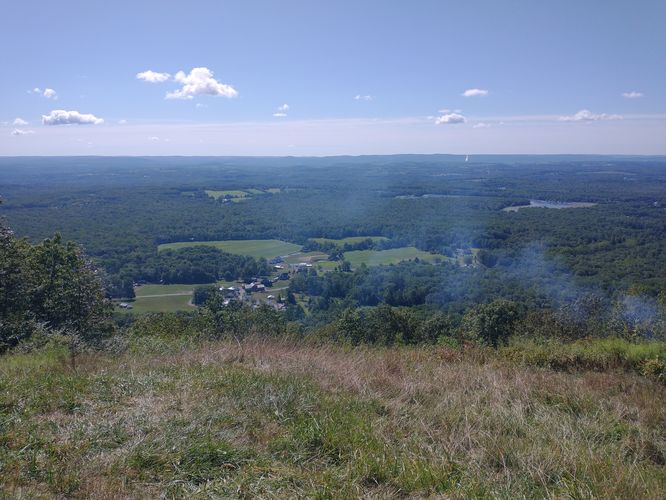
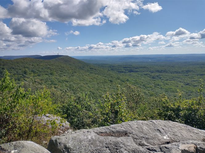
As we hiked we passed two sets of Thru-hikers and were amazed at the pace they hiked and the packs they carried. The trail substrate is easy to traverse and our pace was pretty steady as we meandered through the forest and headed to our first stop at “Lunch Rocks Overlook”. The views from this Overlook are really lovely. It really is a great spot to have a picnic lunch. This could be a nice short out and back hike all on its own.
After enjoying the views and our lunch, we packed up and made our way down the trail to Tott’s Gap. We had some steeper sections on this part of the hike, and a bit of rock scrambles as well. Nothing was too severe or lasted for any great length, but caution is warranted on these sections, not only because of the footing, but because this is snake habitat, and poisonous snakes live here. If you use your hands to help navigate the rocky sections, be careful where you place them.
We reached the junction of Tott's Gap Hill Road and headed downhill and to the right. The substrate here is pretty slick because the road is not maintained, has a steep incline and the substrate is made up of very loose rock. Watch your step and take your time.
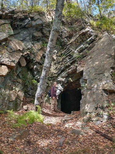
We reached our second goal fairly quickly as the abandoned mine is less than a quarter of a mile down the road and on the right. It’s pretty big, so it’s not hard to find. We ventured inside the mine and took a look around. Our lights, wild imagination and a little bit of fear kept us from going all the way back into the cave, but what we were able to safely explore was fun. After spending a few minutes snapping pictures, we headed back up Tott's Gap Road and back on to the Appalachian Trail to head back toward Route 191.
It was a fun trail to hike with some beautiful views, a cool cave and the novelty of being able to say “we hiked on the Appalachian Trail”. We would definitely recommend this short hike.