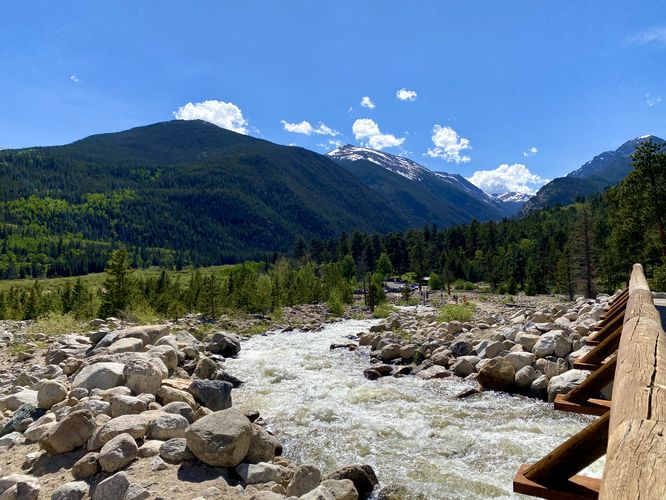
The Alluvial Fan Waterfall (East) at Rocky Mountain National Park near Estes Park, Colorado is an easy 0.4-mile out-and-back hike that leads to an alluvial fan with a roaring waterfall that cascades down Bighorn Mountain.
Universally Accessible
This paved, universally-accessible, trail includes a steep but short 19% grade almost immediately at the parking lot. Note that if you wish to follow a universally-accessible trail up to the Alluvial Fan by skipping the 19% grade section of the trail, you can hike in from the Western parking lot instead.
Hike
This very short hike follows a paved path the entire way (excluding the off-trail hike to a better view of the falls). The trail, from the eastern parking lot, follows a 19% grade for a very short length before it levels out and follows a mostly-flat trail as it leads up the southern slopes of Bighorn Mountain to reach a view of the Alluvial Fan from a distance. Along the way are several different views - some of the Endovalley, surrounded by Sundance Mountain and Mount Chapin.
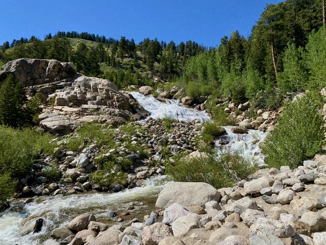
Alluvial Fan Waterfall (approx. 40-feet tall) - Mile 0.2
Around mile 0.2, hikers will reach the end of the trail's paved surface. Here, you can hike off-trail to reach a better view of the waterfall as it cascades down the alluvial fan. The waterfall is about 40-feet tall from what you can view from the end of the trail. The water starts much higher and even cascades down a waterfall high on the mountain called Horseshoe Falls; however, that waterfall is not visible from this trail.
After exploring the Alluvial Fan Waterfall, hikers will head back to parking to complete the hike for approximately 0.45 miles.
What is an Alluvial Fan?
An alluvial fan is a natural feature that occurs when water flows down a steep slope to a flatter plain, carrying with it sand, rocks, boulders, and debris. "Alluvial", refers to the alluvium, or debris, that's carried by the water. When the water reaches a flatter landscape, it loses speed and energy needed to continue carrying the alluvium. As a result, the water begins to spread out and creates a "fan" shaped area of deposition.
Wildlife Viewing
This trail is great for viewing wildlife, especially deer, elk, and moose due to the creek's water source for drinking. If you wish to spot wildlife, your best chances are in the early morning or in the early evening. Always keep a safe distance while viewing - approx. 75-feet for elk and longhorn sheep; 120-feet for bear and moose.
Pets
Dogs are not allowed on this trail.
Parking
Hikers will find a massive parking lot at the coordinates provided, located off of Old Fall River Road at the Alluvial Fan East section. The lot is large enough to fit a couple dozen vehicles. For more parking and another trail entrance to the same waterfall, you can drive west along Old Fall River Road to find the Alluvial Fan West trailhead.
Timed-Entry Reservations
Between the months of late May through early October you must purchase a timed-entry pass to visit Rocky Mountain National Park. If you wish to visitor and hike anything off of the Bear Lake Road, you must purchase a dedicated Bear Lake timed-entry pass. You can find more information about timed entry on the park's website.
Warnings
Elevation sickness: This trail brings hikers through terrain that ascends up to 8,600-feet above sea level. Around the 7,000-foot mark above sea level, hikers may start to experience symptoms of elevation sickness including headache, muscle aches, shortness of breath, among other warning signs. In order to avoid elevation sickness it's recommended to ascend to higher elevations and take short walks to acclimate over the course of several days before taking a long or physically-demanding hike. At any time you feel elevation sickness kicking in, that's the time to turn back and head for lower altitude or the parking lot.
Wild animals: While rare, hikers may encounter bears or mountain lion along the trail. Again, this is rare due to the insane amount of people who hike these trails each day; however, it's smart to know that these wild animals could be on-trail. Please read-up on how to properly handle a bear or mountain lion encounter before hitting the trails.
Universally Accessible
This paved, universally-accessible, trail includes a steep but short 19% grade almost immediately at the parking lot. Note that if you wish to follow a universally-accessible trail up to the Alluvial Fan by skipping the 19% grade section of the trail, you can hike in from the Western parking lot instead.
Hike
This very short hike follows a paved path the entire way (excluding the off-trail hike to a better view of the falls). The trail, from the eastern parking lot, follows a 19% grade for a very short length before it levels out and follows a mostly-flat trail as it leads up the southern slopes of Bighorn Mountain to reach a view of the Alluvial Fan from a distance. Along the way are several different views - some of the Endovalley, surrounded by Sundance Mountain and Mount Chapin.
Alluvial Fan Waterfall (approx. 40-feet tall) - Mile 0.2
Around mile 0.2, hikers will reach the end of the trail's paved surface. Here, you can hike off-trail to reach a better view of the waterfall as it cascades down the alluvial fan. The waterfall is about 40-feet tall from what you can view from the end of the trail. The water starts much higher and even cascades down a waterfall high on the mountain called Horseshoe Falls; however, that waterfall is not visible from this trail.
After exploring the Alluvial Fan Waterfall, hikers will head back to parking to complete the hike for approximately 0.45 miles.
What is an Alluvial Fan?
An alluvial fan is a natural feature that occurs when water flows down a steep slope to a flatter plain, carrying with it sand, rocks, boulders, and debris. "Alluvial", refers to the alluvium, or debris, that's carried by the water. When the water reaches a flatter landscape, it loses speed and energy needed to continue carrying the alluvium. As a result, the water begins to spread out and creates a "fan" shaped area of deposition.
Wildlife Viewing
This trail is great for viewing wildlife, especially deer, elk, and moose due to the creek's water source for drinking. If you wish to spot wildlife, your best chances are in the early morning or in the early evening. Always keep a safe distance while viewing - approx. 75-feet for elk and longhorn sheep; 120-feet for bear and moose.
Pets
Dogs are not allowed on this trail.
Parking
Hikers will find a massive parking lot at the coordinates provided, located off of Old Fall River Road at the Alluvial Fan East section. The lot is large enough to fit a couple dozen vehicles. For more parking and another trail entrance to the same waterfall, you can drive west along Old Fall River Road to find the Alluvial Fan West trailhead.
Timed-Entry Reservations
Between the months of late May through early October you must purchase a timed-entry pass to visit Rocky Mountain National Park. If you wish to visitor and hike anything off of the Bear Lake Road, you must purchase a dedicated Bear Lake timed-entry pass. You can find more information about timed entry on the park's website.
Warnings
Elevation sickness: This trail brings hikers through terrain that ascends up to 8,600-feet above sea level. Around the 7,000-foot mark above sea level, hikers may start to experience symptoms of elevation sickness including headache, muscle aches, shortness of breath, among other warning signs. In order to avoid elevation sickness it's recommended to ascend to higher elevations and take short walks to acclimate over the course of several days before taking a long or physically-demanding hike. At any time you feel elevation sickness kicking in, that's the time to turn back and head for lower altitude or the parking lot.
Wild animals: While rare, hikers may encounter bears or mountain lion along the trail. Again, this is rare due to the insane amount of people who hike these trails each day; however, it's smart to know that these wild animals could be on-trail. Please read-up on how to properly handle a bear or mountain lion encounter before hitting the trails.