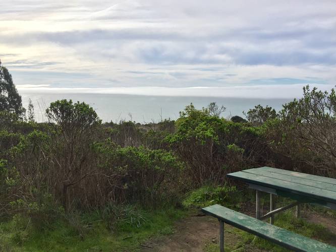
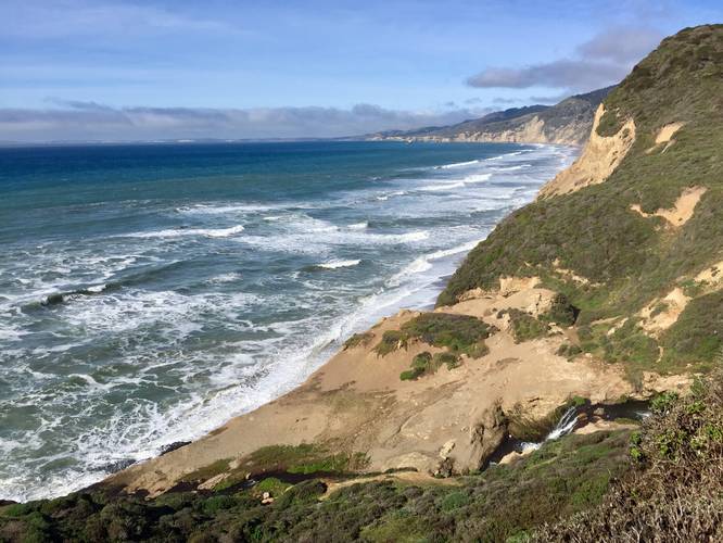
The Alamere Falls Vista via Coast Trail at Point Reyes National Seashore near Bolinas, California is a moderate 8.8-mile out-and-back hike that leads to a beautiful vista point above Alamere Falls. This hike also features two scenic lake vistas that sit at the edge of these cliff sides - Bass Lake and Pelican Lake. Before planning this hike, please be aware of the warnings and dangers associated with hiking to this vista point. This is not the trail that leads to the base of Alamere Falls - more information can be found below.
This hike starts out at the Palomarin Trailhead, which leads down to the Palomarin Beach; however, hikers will start at this trailhead and follow the Coast Trail the entire length of the hike. The Coast Trail is easy to follow since each of the trail junctions along the way have signage - the only tricky part to this hike is finding the offshoot that leads to the Alamere Falls vista (see Finding the Vista Trail below).
The first section of the trail leads hikers through a beautiful old-growth eucalyptus forest which boasts massive trees that give off a wonderful scent. Within the eucalyptus forest is a trail junction with the Palomarin Trail where it leads downhill toward Palomarin Beach.
Shortly after the eucalyptus forest, the trail starts to follow cliff sides and creek ravines where the trail will weave in and out from the coast. These ravines have some elevation change to them, but they're not very difficult to hike.
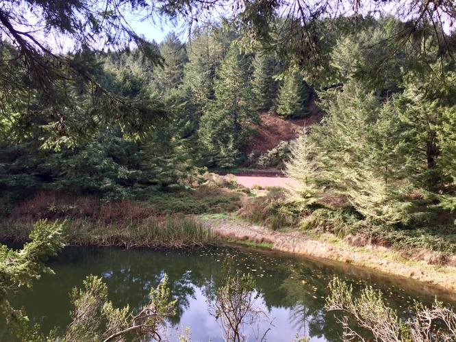
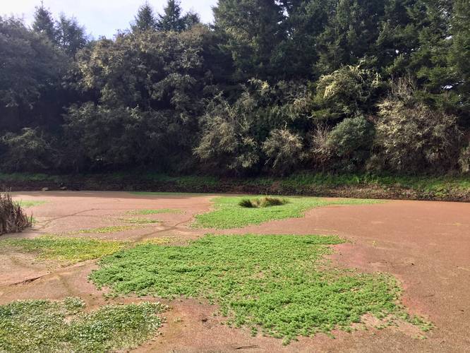
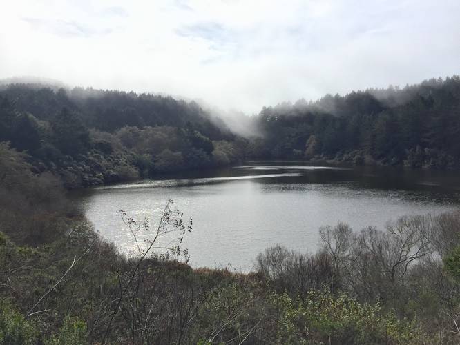
At about 1.4-miles into the hike, the trail will head up a moderate grade for quite some time where it leads further into the woods and away from the coast. Here is where the trail will run adjacent to some small ponds, Bass Lake, and eventually Pelican Lake.
Shortly after Pelican Lake is the spur trail that leads to the lookout point above Alamere Falls. At Alamere Falls, hikers can often find several sketchy trails that lead downhill with better views of the falls; however, it's not recommended to follow these to keep safe.
The hike back is exactly the same as the hike in. Hike at your own risk and enjoy the beautiful California coastline.
Finding the Vista Trail
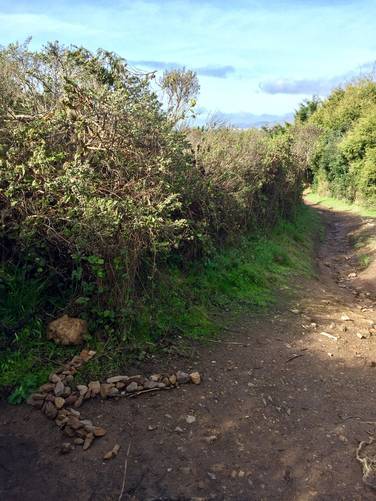
Just after hiking past Pelican Lake, the trail makes a sharp right-hand curve. Immediately after this right-hand curve is what looks like a deer trail to the left-hand side. When we hiked this trail, there was an arrow made of rocks that pointed the way down this skinny trail. If you follow this spur trail, despite the overgrowth, it leads out to a stunning vista point above Alamere Falls, technically Upper Alamere Falls. The trail follows underneath trees until it opens up to a more open section. Where there opens up are several trails to follow, but stay to the right and head north to find the lookout point.
Parking
Hikers can find a very large parking lot at the coordinates provided.
Amenities
There are two bathrooms for hikers at the parking lot.
Warning
This hike to the top of Alamere Falls is not the same as the hike out to the base of Alamere Falls. There are no clear and safe paths for hikers to reach the base of Alamere Falls from this trail. Trailhead signs claim that visitors get hurt here on a weekly basis, so do not hike down risky slopes near cliffs. Additionally, there are plenty of sheer cliff drops along the trail at various points - watch your step and stay away from the cliff's edge. Hike at your own risk. Warning from the Point Reyes National Seashore Facebook account: 'Please note this is not the authorized trail to Alamere Falls. The proper routes to Alamere Falls will get you to Wildcat Campground and then you'll walk along the beach to get to the bottom of the falls. Being above the falls is dangerous and visitors that take this unauthorized route may endanger themselves and rescuers, and inadvertently cause resource damage. Please check out our website for the recommended routes: https://www.nps.gov/pore/planyourvisit/alamere_falls.htm. Thank you! (sc)' -- for more information please see our Facebook post.
Tides
Also note that during high tide, the base of Alamere Falls is inaccessible and extremely dangerous because the waves crash right up against the cliffs. If you wish to make your way to the base of Alamere Falls, plan on reaching the falls for exactly low tide. Also note that we did not try to descent the hills along Alamere Falls, so this guide should not be the only guide hikers use if they wish to find the base of Alamere Falls.
Pets
Dogs are not allowed on this trail.
This hike starts out at the Palomarin Trailhead, which leads down to the Palomarin Beach; however, hikers will start at this trailhead and follow the Coast Trail the entire length of the hike. The Coast Trail is easy to follow since each of the trail junctions along the way have signage - the only tricky part to this hike is finding the offshoot that leads to the Alamere Falls vista (see Finding the Vista Trail below).
The first section of the trail leads hikers through a beautiful old-growth eucalyptus forest which boasts massive trees that give off a wonderful scent. Within the eucalyptus forest is a trail junction with the Palomarin Trail where it leads downhill toward Palomarin Beach.
Shortly after the eucalyptus forest, the trail starts to follow cliff sides and creek ravines where the trail will weave in and out from the coast. These ravines have some elevation change to them, but they're not very difficult to hike.
At about 1.4-miles into the hike, the trail will head up a moderate grade for quite some time where it leads further into the woods and away from the coast. Here is where the trail will run adjacent to some small ponds, Bass Lake, and eventually Pelican Lake.
Shortly after Pelican Lake is the spur trail that leads to the lookout point above Alamere Falls. At Alamere Falls, hikers can often find several sketchy trails that lead downhill with better views of the falls; however, it's not recommended to follow these to keep safe.
The hike back is exactly the same as the hike in. Hike at your own risk and enjoy the beautiful California coastline.
Finding the Vista Trail
Just after hiking past Pelican Lake, the trail makes a sharp right-hand curve. Immediately after this right-hand curve is what looks like a deer trail to the left-hand side. When we hiked this trail, there was an arrow made of rocks that pointed the way down this skinny trail. If you follow this spur trail, despite the overgrowth, it leads out to a stunning vista point above Alamere Falls, technically Upper Alamere Falls. The trail follows underneath trees until it opens up to a more open section. Where there opens up are several trails to follow, but stay to the right and head north to find the lookout point.
Parking
Hikers can find a very large parking lot at the coordinates provided.
Amenities
There are two bathrooms for hikers at the parking lot.
Warning
This hike to the top of Alamere Falls is not the same as the hike out to the base of Alamere Falls. There are no clear and safe paths for hikers to reach the base of Alamere Falls from this trail. Trailhead signs claim that visitors get hurt here on a weekly basis, so do not hike down risky slopes near cliffs. Additionally, there are plenty of sheer cliff drops along the trail at various points - watch your step and stay away from the cliff's edge. Hike at your own risk. Warning from the Point Reyes National Seashore Facebook account: 'Please note this is not the authorized trail to Alamere Falls. The proper routes to Alamere Falls will get you to Wildcat Campground and then you'll walk along the beach to get to the bottom of the falls. Being above the falls is dangerous and visitors that take this unauthorized route may endanger themselves and rescuers, and inadvertently cause resource damage. Please check out our website for the recommended routes: https://www.nps.gov/pore/planyourvisit/alamere_falls.htm. Thank you! (sc)' -- for more information please see our Facebook post.
Tides
Also note that during high tide, the base of Alamere Falls is inaccessible and extremely dangerous because the waves crash right up against the cliffs. If you wish to make your way to the base of Alamere Falls, plan on reaching the falls for exactly low tide. Also note that we did not try to descent the hills along Alamere Falls, so this guide should not be the only guide hikers use if they wish to find the base of Alamere Falls.
Pets
Dogs are not allowed on this trail.