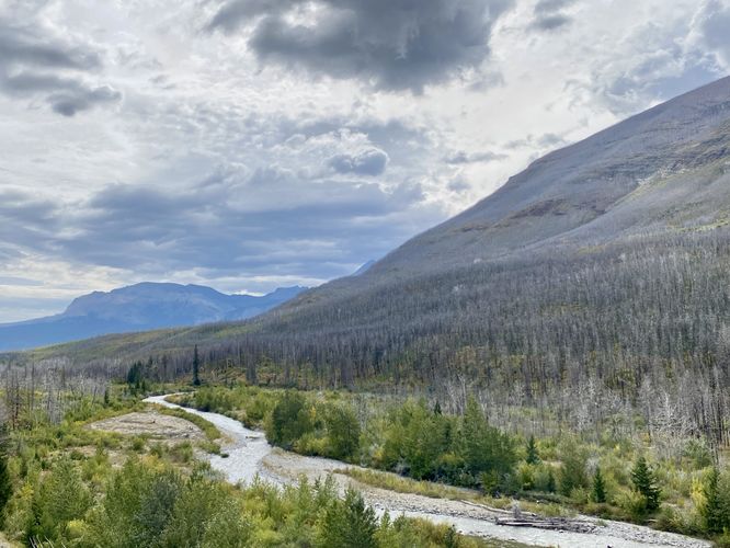
The Akaitapi Lookout at Waterton Lakes National Park near Waterton Park, Alberta is an easy 0.2 km out-and-back trail that leads to a viewpoint high above Bauerman Creek and features views of the creek and Mount Blakiston.
From the end of the trail, visitors will find a viewing platform with the Bauerman Creek below their feet. You'll also find views that face east and west along with signage that depicts the local flora. As of September 2024, the area is still covered in dead standing trees that are left over from the 2017 wildfire, however, the forest is recovering with mountainsides full of saplings, shrubs, and new growth on the forest floor.
As well, the oral tradition of both the Piikani and Ktunaxa mentions camps and activities in the Waterton area. Bison were vital to these peoples. They followed when the bison moved in response to weather, availability of water and suitable grass, and pressure from predators. Hunting typically involved driving bison over cliffs or into corrals, wetlands and snow drifts. Aboriginal peoples also travelled seasonally to gather plants, for ceremonies, and to hunt other animals like elk; deer, bighorn sheep and moose.
The Blakiston Valley was a major travel route. The South Kootenay Pass, just west of here, was widely used by the Kunaxa, and other tribes in what is now British Columbia and Montana, to reach bison on the plains and to trade.
The Piikani also used this pass, travelling from east to west to trade.
If you were travelling here 8,000 years ago, you might have sat by a campfire roasting bison and sharing stories.
Radiocarbon tests indicate a base camp was located at Red Rock Canyon that long ago. It was likely used for hunting and when travelling over the mountains."
From the end of the trail, visitors will find a viewing platform with the Bauerman Creek below their feet. You'll also find views that face east and west along with signage that depicts the local flora. As of September 2024, the area is still covered in dead standing trees that are left over from the 2017 wildfire, however, the forest is recovering with mountainsides full of saplings, shrubs, and new growth on the forest floor.
Akaitapi (Good Campsite)
From the park's signage: "Archaeologists have found evidence of Aboriginal campsites throughout the park.As well, the oral tradition of both the Piikani and Ktunaxa mentions camps and activities in the Waterton area. Bison were vital to these peoples. They followed when the bison moved in response to weather, availability of water and suitable grass, and pressure from predators. Hunting typically involved driving bison over cliffs or into corrals, wetlands and snow drifts. Aboriginal peoples also travelled seasonally to gather plants, for ceremonies, and to hunt other animals like elk; deer, bighorn sheep and moose.
The Blakiston Valley was a major travel route. The South Kootenay Pass, just west of here, was widely used by the Kunaxa, and other tribes in what is now British Columbia and Montana, to reach bison on the plains and to trade.
The Piikani also used this pass, travelling from east to west to trade.
If you were travelling here 8,000 years ago, you might have sat by a campfire roasting bison and sharing stories.
Radiocarbon tests indicate a base camp was located at Red Rock Canyon that long ago. It was likely used for hunting and when travelling over the mountains."