Adams Falls Trail at Rocky Mountain National Park in Grand Lake, Colorado is a moderate 0.8-mile out-and-back hike that features views of the multi-tiered waterfall, Adams Falls, in addition to views of Grand Lake and the surrounding mountains.
Hike
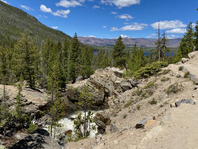
This hike begins at the very large parking lot for Adams Falls and the East Inlet Trail. The trailhead is located on the southeast side of the parking lot and the trail begins by following a dirt path as it enters the forest. The trail quickly turns into less of a gradual walk and more of a rocky uphill hike fairly quickly. It follows a couple of switchback-like turns to reach a plateau of bedrock just north of Adams Falls. Hikers will find plenty of signage along the way, so just follow the arrows on the Adams Falls signs.
Adams Falls - Mile 0.35
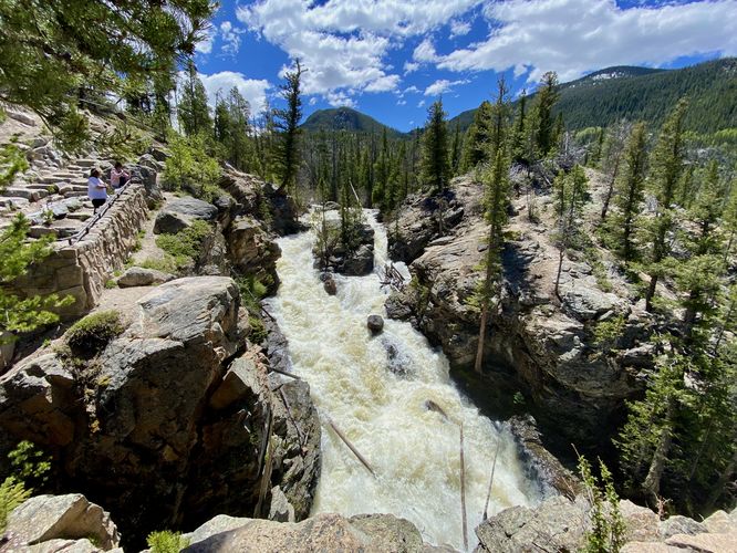
At mile 0.35, hikers will reach a viewing platform high above Adams Falls with the multi-tiered waterfall cascading below your feet. During snow melt season or after periods of rainfall, the waterfall roars down the East Inlet Creek at amazing velocities. There are plenty of signs to remind hikers to stay-back and for very good reason as the drop into this roaring waterfall is at least over 30-feet deep from the cliff's edge.
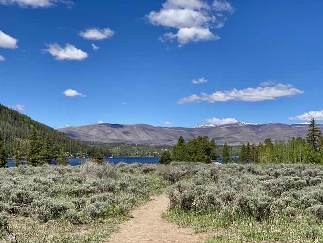
Grand Lake View - Mile 0.35
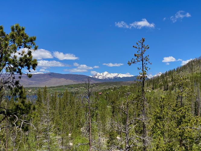
Before you take-off from Adams Falls, just behind the waterfall's viewpoint is another view -- that of Grand Lake and its surrounding mountains in the distance.
After exploring the views and the waterfall, hikers can choose to continue along the East Inlet Trail for a long day hike or follow this route back to parking. The track leads hikers up the East Inlet Creek's gorge before taking a left-hand turn back onto the East Inlet Trail to head back to parking for a 0.8-mile out-and-back (lollipop) hike.
Restrooms
There are pit toilets with hand sanitizer located at the trailhead, as of June 2024.
Pets
Dogs are not allowed on this trail.
Parking
Hikers will find a large parking lot at the coordinates provided, located near the end of West Portal Road in Grand Lake, CO. The lot is large enough to fit many dozens of vehicles.
Wildlife Viewing
This trail is great for viewing wildlife, especially deer, elk, and moose due to the creek's water source for drinking. If you wish to spot wildlife, your best chances are in the early morning or in the early evening. Always keep a safe distance while viewing - approx. 75-feet for elk and longhorn sheep; 120-feet for bear and moose.
Timed-Entry Reservations
Between the months of late May through early October you must purchase a timed-entry pass to visit Rocky Mountain National Park. If you wish to visitor and hike anything off of the Bear Lake Road, you must purchase a dedicated Bear Lake timed-entry pass. You can find more information about timed entry on the park's website.
Warnings
Elevation sickness: This trail brings hikers through terrain that ascends up to 8,500-feet above sea level. Around the 7,000-foot mark above sea level, hikers may start to experience symptoms of elevation sickness including headache, muscle aches, shortness of breath, among other warning signs. In order to avoid elevation sickness it's recommended to ascend to higher elevations and take short walks to acclimate over the course of several days before taking a long or physically-demanding hike. At any time you feel elevation sickness kicking in, that's the time to turn back and head for lower altitude or the parking lot.
Wild animals: While rare, hikers may encounter bears or mountain lion along the trail. Again, this is rare due to the insane amount of people who hike these trails each day; however, it's smart to know that these wild animals could be on-trail. Please read-up on how to properly handle a bear or mountain lion encounter before hitting the trails.
Cliffs: This trail leads hikers directly to a very-steep cliff where Adams Falls plunges through a gorge. Stay back for your own safety.
Hike
This hike begins at the very large parking lot for Adams Falls and the East Inlet Trail. The trailhead is located on the southeast side of the parking lot and the trail begins by following a dirt path as it enters the forest. The trail quickly turns into less of a gradual walk and more of a rocky uphill hike fairly quickly. It follows a couple of switchback-like turns to reach a plateau of bedrock just north of Adams Falls. Hikers will find plenty of signage along the way, so just follow the arrows on the Adams Falls signs.
Adams Falls - Mile 0.35
At mile 0.35, hikers will reach a viewing platform high above Adams Falls with the multi-tiered waterfall cascading below your feet. During snow melt season or after periods of rainfall, the waterfall roars down the East Inlet Creek at amazing velocities. There are plenty of signs to remind hikers to stay-back and for very good reason as the drop into this roaring waterfall is at least over 30-feet deep from the cliff's edge.
Grand Lake View - Mile 0.35
Before you take-off from Adams Falls, just behind the waterfall's viewpoint is another view -- that of Grand Lake and its surrounding mountains in the distance.
After exploring the views and the waterfall, hikers can choose to continue along the East Inlet Trail for a long day hike or follow this route back to parking. The track leads hikers up the East Inlet Creek's gorge before taking a left-hand turn back onto the East Inlet Trail to head back to parking for a 0.8-mile out-and-back (lollipop) hike.
Restrooms
There are pit toilets with hand sanitizer located at the trailhead, as of June 2024.
Pets
Dogs are not allowed on this trail.
Parking
Hikers will find a large parking lot at the coordinates provided, located near the end of West Portal Road in Grand Lake, CO. The lot is large enough to fit many dozens of vehicles.
Wildlife Viewing
This trail is great for viewing wildlife, especially deer, elk, and moose due to the creek's water source for drinking. If you wish to spot wildlife, your best chances are in the early morning or in the early evening. Always keep a safe distance while viewing - approx. 75-feet for elk and longhorn sheep; 120-feet for bear and moose.
Timed-Entry Reservations
Between the months of late May through early October you must purchase a timed-entry pass to visit Rocky Mountain National Park. If you wish to visitor and hike anything off of the Bear Lake Road, you must purchase a dedicated Bear Lake timed-entry pass. You can find more information about timed entry on the park's website.
Warnings
Elevation sickness: This trail brings hikers through terrain that ascends up to 8,500-feet above sea level. Around the 7,000-foot mark above sea level, hikers may start to experience symptoms of elevation sickness including headache, muscle aches, shortness of breath, among other warning signs. In order to avoid elevation sickness it's recommended to ascend to higher elevations and take short walks to acclimate over the course of several days before taking a long or physically-demanding hike. At any time you feel elevation sickness kicking in, that's the time to turn back and head for lower altitude or the parking lot.
Wild animals: While rare, hikers may encounter bears or mountain lion along the trail. Again, this is rare due to the insane amount of people who hike these trails each day; however, it's smart to know that these wild animals could be on-trail. Please read-up on how to properly handle a bear or mountain lion encounter before hitting the trails.
Cliffs: This trail leads hikers directly to a very-steep cliff where Adams Falls plunges through a gorge. Stay back for your own safety.