Timmerman Trail
Distance:
1.2 Miles / 1.9 kmType:
Out-and-BackDifficulty:
EasyTime to Hike:
~36 minutesFeatures:
Surface Type:
Universal AccessLoading...
Loading...
The Timmerman Trail at Congaree Creek Heritage Preserve in Cayce, South Carolina is an easy 1.2-mile out-and-back walk that follows a universally accessible and paved pathway through the forest.
Walk
This walk begins at the western trailhead for the Timmerman Trail on the west side of SC-35. The Timmerman Trail follows a paved, universally accessible, pathway throughout (with small sections of boardwalk) and has very minimal elevation change. The trail starts by heading into the woods before passing under the SC-35 bridge. This section of the walk can be a bit noisy, but it quiets down once you get further away from the main road. The path then encompasses the northern side of the Lexington Medical Center (as of March 2024) before heading back into the woods. On the southern side of the trail, Congaree Creek bends around the forest and meets with the trail in several places, providing viewpoint opportunities. While the views here are not grandeur or sweeping valley views, the views of the creek allow for short scenic breaks along this otherwise mundane forest trail.
This section of the trail was only mapped to mile 0.6 from the trailhead before we turned back to parking. Despite the short length, this is a great place to take a short stroll.
Universal Access
This trail, as of March 2024, is universally accessible and follows a paved surface for most of the trail. There are some boardwalk bridges that are universally accessible, located south of the medical center.
Parking
Walkers will find a large parking lot at the coordinates provided, located on the west side of SC-35 and Ottare Parkway in Cayce, SC. The lot is large enough to fit several dozen vehicles.
Warning
Alligators: This creek is known to be an alligator habitat. There's a large fence that spans the trail near the bridge underpass that might prevent some alligators from reaching the trail; however, other portions of the trail pass near Congaree Creek's banks. Be on the lookout for alligators and give any you find plenty of space (approx. 60-feet for large garors).
Timber Rattlesnakes: This area is home to the Timber Rattlesnake which can be found drinking or hunting near creeks especially during warmer months of the year. Be on the lookout and give any rattlers you find plenty of space.
-
Parking
33.942071, -81.044551 -
Main Trailhead
33.942071, -81.044551 -
Conagree Creek view
33.941247, -81.039733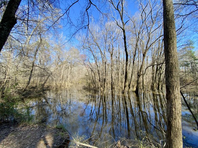
Hazards
Seasons
All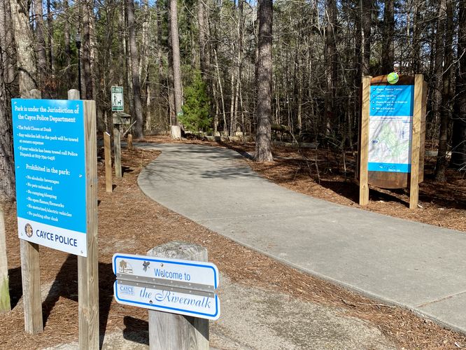
1 Trip Report


Helpful Links
Find Hiking Trails Near Me:


Before you leave...
MyHikes is an indie web platform aimed to make exploring public trails easier for everyone. The site has no investors and is owned and operated by one person, Dave Miller (Founder & Admin). As the Founder, main contributor, and doer-of-all-things for MyHikes, I share my trips with over-detailed write-ups for fun on a volunteer basis and I believe that public trail information should be available to everyone.
It takes a lot of time 🕦, money 💰, and effort (including espresso shots ☕) to run MyHikes, including hiking , mapping , writing , and publishing new trails with high-quality content... along with building new features, moderating, site maintainance, and app development for iOS and Android . I simply ask that if you find MyHikes' trail guides helpful to please consider becoming a Supporter to help keep the site, iOS, and Android apps available to everyone.
Supporters unlock website and in-app perks with a one-time payment of $25 (you renew) 😎👍. Or you can simply make a Donation of your choice without a MyHikes user account. Otherwise, telling your friends about MyHikes is the next-best thing - both quick and free 🎉
Thanks for visiting MyHikes and have a great hike!️

Dave Miller
MyHikes Founder & Admin

