Round the Mountain Trail via South Climb
Distance:
10.1 Miles / 16.3 kmType:
Out-and-BackDifficulty:
HardTime to Hike:
5 hours, ~5 minutesFeatures:
Surface Type:
DirtLoading...
Loading...
A spectacular treeline hike across the volcanic landscapes and glacial-avalanche debris fields on Mount Adams' southwest face.
WARNING FALL–WINTER 2017:
(Avoid it this summer due to a piece of ice wanting to break free from Avalanche Glacier, as advised by Darryl Lloyd via the Gifford Pinchot National Forest. Wait until after it breaks free and once the risk has passed. By this time next year, it should have already broken free and caused an avalanche. Once the event has passed and any potential repairs to the trail are made it should be completely safe.)
Take the South Climb Trail to the junction with the Round the Mountain Trail #9. Turn left (west) onto the Round the Mountain Trail and cross numerous creeks before reaching the Shorthorn Trail. Just before the junction, the trail crosses over Crofton Creek. Along the way, the landscape changes from dry and sandy to lush and green, and crosses several creeks–the largest one being Morrison Creek. The trail crosses in and out of the 2012 Cascade Creek Fire that burned 20,000 acres–the second largest fire on Mount Adams to date. Even though some of it is burned, the beauty remains intact. Much of the trail was spared from the fire and remains alive and well!
Pass the junction with Shorthorn Trail #16 and continue along the trail. Views of Mount Adams greet you at almost every bend of the trail. Note how the soil changes from sandy grey to bright yellow/orange. This is due to the sulfur that broke free with past glacial and rock avalanches from Avalanche Glacier above. From here, the trail crosses several larger glacial creeks, many of them tributaries of Salt Creek. Each creek carves an impressive canyon of its own.
Optional:
After crossing Salt Creek and two of it's smaller tribitaries, you can make the optional spur to a unique waterfall tumbling off a sulfur-stained ledge below the southwest face of Adams and Avalanche Glacier. As you hike up, the trees thin out to a world of red rocks and yellow-orange soil.
Turn back the way you came, rejoining the Round the Mountain Trail and take it back to the South Climb Trail. Turn right onto the South Climb Trail to reach the South Climb Trailhead.
Note: The last half mile to the Avalanche Glacier debris field and the falls is off-trail, but completely avoidable if cross country hiking isn't what you're comfortable with. Just end wherever you feel like on the Round the Mountain Trail and head back to the trailhead.
Hazards
Seasons
Summer, Fall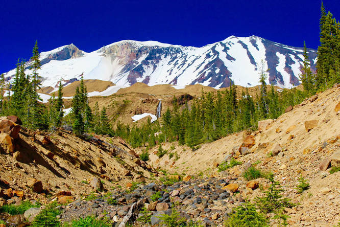
1 Trip Report


Helpful Links
Find Hiking Trails Near Me:


")


Before you leave...
MyHikes is an indie web platform aimed to make exploring public trails easier for everyone. The site has no investors and is owned and operated by one person, Dave Miller (Founder & Admin). As the Founder, main contributor, and doer-of-all-things for MyHikes, I share my trips with over-detailed write-ups for fun on a volunteer basis and I believe that public trail information should be available to everyone.
It takes a lot of time 🕦, money 💰, and effort (including espresso shots ☕) to run MyHikes, including hiking , mapping , writing , and publishing new trails with high-quality content... along with building new features, moderating, site maintainance, and app development for iOS and Android . I simply ask that if you find MyHikes' trail guides helpful to please consider becoming a Supporter to help keep the site, iOS, and Android apps available to everyone.
Supporters unlock website and in-app perks with a one-time payment of $25 (you renew) 😎👍. Or you can simply make a Donation of your choice without a MyHikes user account. Otherwise, telling your friends about MyHikes is the next-best thing - both quick and free 🎉
Thanks for visiting MyHikes and have a great hike!️

Dave Miller
MyHikes Founder & Admin

