Herman Creek Trail
Distance:
9.2 Miles / 14.8 kmType:
Out-and-BackDifficulty:
HardTime to Hike:
4 hours, ~36 minutesFeatures:
Surface Type:
DirtLoading...
Loading...
This is a great hike in the eastern side of the Columbia River Gorge, but unfortunately, the Eagle Creek Fire passed through this area in late Summer of 2017 that burned over 40,000 acres in the Columbia River Gorge National Scenic Area and countless miles of trails.
The trail climbs steeply at first, then flattens out some as it follows high above the Herman Creek canyon. It passes through a semi-lush rainforest environment for most of its route, save for a few dry and grassy areas, where you will pass through Oregon White Oaks.
Once the Forest Service considers it safe to enter post-fire next season, they will hopefully reopen the trail for hiking. When hiking post-fire, be cautious around burned dead snags and unstable soil. They can be potentially hazardous on windy days or during/after a rainstorm.
Hazards
Seasons
All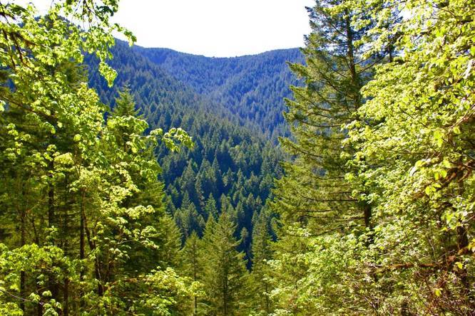
1 Trip Report


Helpful Links
Find Hiking Trails Near Me:


Before you leave...
MyHikes is an indie web platform aimed to make exploring public trails easier for everyone. The site has no investors and is owned and operated by one person, Dave Miller (Founder & Admin). As the Founder, main contributor, and doer-of-all-things for MyHikes, I share my trips with over-detailed write-ups for fun on a volunteer basis and I believe that public trail information should be available to everyone.
It takes a lot of time 🕦, money 💰, and effort (including espresso shots ☕) to run MyHikes, including hiking , mapping , writing , and publishing new trails with high-quality content... along with building new features, moderating, site maintainance, and app development for iOS and Android . I simply ask that if you find MyHikes' trail guides helpful to please consider becoming a Supporter to help keep the site, iOS, and Android apps available to everyone.
Supporters unlock website and in-app perks with a one-time payment of $25 (you renew) 😎👍. Or you can simply make a Donation of your choice without a MyHikes user account. Otherwise, telling your friends about MyHikes is the next-best thing - both quick and free 🎉
Thanks for visiting MyHikes and have a great hike!️

Dave Miller
MyHikes Founder & Admin

