Blue Hen Falls
Distance:
0.4 Miles / 0.6 kmType:
Out-and-BackDifficulty:
ModerateTime to Hike:
~12 minutesFeatures:
Surface Type:
DirtTown:
Brecksville, OhioLoading...
Loading...
The Blue Hen Falls Trail in Cuyahoga Valley National Park, OH, is an easy 0.4 mile out-and-back hike down to the falls.
Blue Hen Falls is an overhanging plate of sandstone protruding from the underlying shale with a 15 foot waterfall. The hike is short and easy, but there is a small semi-steep hill you have to hike back up to get to parking, so this trail is not fully accessible.
When you reach the lookout point above Blue Hen Falls, you'll find a small trail that also leads down to the falls. Hiking down gets you a different perspective and you can even hike behind the falls.
Season
Summer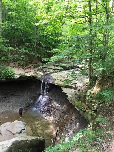
3 Trip Reports


Helpful Links
Find Hiking Trails Near Me:


Before you leave...
MyHikes is an indie web platform aimed to make exploring public trails easier for everyone. The site has no investors and is owned and operated by one person, Dave Miller (Founder & Admin). As the Founder, main contributor, and doer-of-all-things for MyHikes, I share my trips with over-detailed write-ups for fun on a volunteer basis and I believe that public trail information should be available to everyone.
It takes a lot of time 🕦, money 💰, and effort (including espresso shots ☕) to run MyHikes, including hiking , mapping , writing , and publishing new trails with high-quality content... along with building new features, moderating, site maintainance, and app development for iOS and Android . I simply ask that if you find MyHikes' trail guides helpful to please consider becoming a Supporter to help keep the site, iOS, and Android apps available to everyone.
Supporters unlock website and in-app perks with a one-time payment of $25 (you renew) 😎👍. Or you can simply make a Donation of your choice without a MyHikes user account. Otherwise, telling your friends about MyHikes is the next-best thing - both quick and free 🎉
Thanks for visiting MyHikes and have a great hike!️

Dave Miller
MyHikes Founder & Admin

